

Explainer: How do earthquakes happen? | Science and Technology
An earthquake, in the simplest terms, is when the earth shakes.
Did you know that there are hundreds of earthquakes every single day, not always strong enough for us to notice them? Then there are some massive ones that cause huge damage and loss of life. These terrifying events raise many questions; here are some answers.
Whose ‘fault’ is it when an earthquake happens?
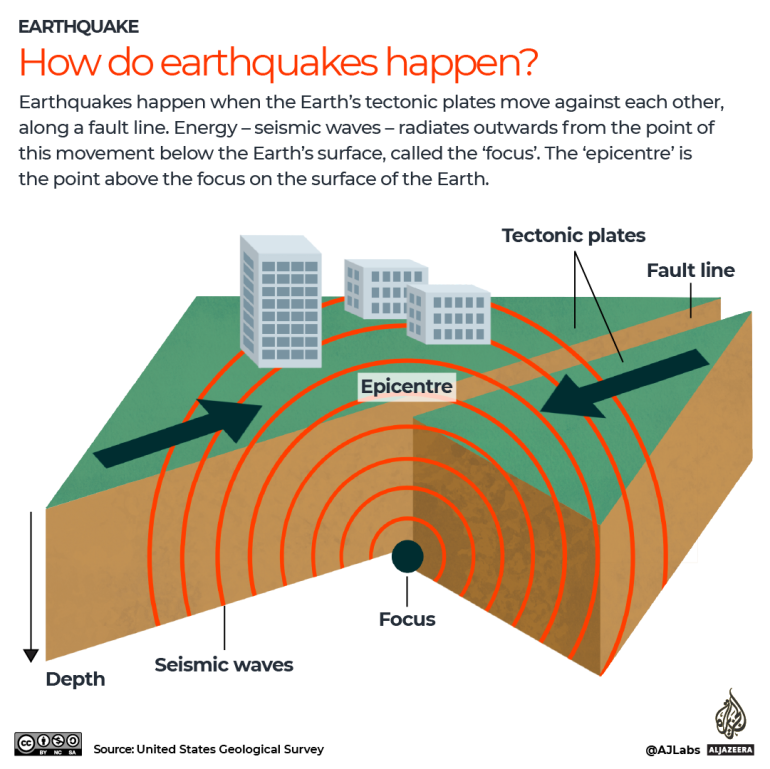
The surface of the Earth is made of kilometres of hard rock broken into a puzzle of moving pieces called tectonic plates, which sit on a sea of hot, liquid rock that rolls as it cools, pushing the plates around. Earthquakes and volcanoes occur on the surface where they meet.
Plates are always technically in motion but are usually locked together, building stress until something underground snaps, freeing them to slide along known lines of fractured rock called faults, that can run for kilometres.
When the pressure suddenly releases and the plate moves, energy explodes into the surrounding rock.
How do you know how strong an earthquake was?
Scientists use seismographs, which used to be wiggling needles that record the ground’s shakes, but now the equipment is all digital. There is a global network of these, as well as local and regional networks, and much of the data is open-source and automatically connected. By combining at least three measurements, systems can map the location, duration and size of an earthquake with precision. Finally, there are a few different measurements of earthquakes, but the most widely used magnitude refers to the overall size, and each step is 10 times greater than the step below.

In addition to seismometers, geologists and seismologists have a variety of tools to collect data about the Earth’s crust’s movements. GPS-connected sensors are placed near seismically active sites to measure movement on the surface. Satellite photos taken before and after an event can be compared pixel-by-pixel. A satellite-based radar called InSAR is one of the most important tools for sensing how the Earth’s surface changes: it reflects beams of radiowaves from orbit over sweeps of the Earth, and a process called interferometry records changes in surface height accurately to millimetres. The satellite passes twice to see what has changed on the ground. Machine learning techniques are also now being tried on large datasets to find signals faster than humans can.
Can one earthquake cause another?
Though earthquakes are known to trigger other earthquakes, how that happens is a territory of fierce discussion among scientists. Earthquakes expose two paradoxes about how humans understand the natural world: they happen over timespans longer than human experience and occur at depths far beyond people’s ability to observe directly.
Scientists manage this by making models and calculating probabilities. After an earthquake, scientists look at the data to better understand what might happen next. “We have to put a stethoscope” on the Earth, said Harold Tobin, professor of Earth Sciences at the University of Washington, “to determine what’s happening down there.
“The broad idea about the cause [of earthquakes] being the buildup of strain has been around for a long time,” Tim Wright of the UK-based Centre for Observation and Modelling of Earthquakes, Volcanoes and Tectonics (COMET) explained, “but only over the last 20 years have we had the technology to measure that using satellite information.”
How do we know if an earthquake is coming?
Scientists are asked all the time whether it is possible to predict an earthquake. “We aren’t anywhere near a short-term forecast,” said Wright. The United States Geological Survey, which documents global seismic events, maintains a webpage devoted to debunking prediction myths.
After a large earthquake, there is a huge amount of data to be collected and deciphered, and some of it is immediately useful. ”We can make calculations about places that are more or less likely to have earthquakes as a result of [another],” said Wright.
He is waiting for InSAR data from a European satellite that will make its first pass over southern Turkey since a series of high-magnitude earthquakes hit on February 6. His team, and others, use these tools to measure how strain builds at known faults. They can model the total amount of energy that might end up being released in an earthquake in a specific area, and the rate at which it will be released, with considerable accuracy.
“But we just don’t know when” it will happen, he said. “We don’t know whether it could be a single magnitude 8 earthquake or ten magnitude 7 earthquakes”.
In areas that are equipped for it, early warnings can be broadcast a few seconds before the shocks hit, to slow trains or open emergency doors.
Surely science can figure this out?
A unique lab in upstate New York simulates earthquakes year round. The University at Buffalo New York’s Structural Engineering and Earthquake Simulation Laboratory (SEESL) has two giant 7×7-metre (23×23-feet) shaking tables, each equipped to hold small buildings, pieces of bridges, or other units of infrastructure. SEESL’s Michel Bruneau said: “It is possible to build structures that can survive this,” referring to a magnitude 7.8 earthquake.
“You can engineer the structure such that the damage is contained, so the occupants can escape”, even for buildings built from reinforced concrete, a material used worldwide, he added.
Engineers can design failure points into the structure by moving them away from the columns that hold the building up and placing them in less critical areas. The next step, Bruneau said, is “the idea of seismic resilience” – buildings that recover. At the lab, they are developing technologies for structures with replaceable parts that concentrate the damage, break, and are then swapped out quickly, maintaining the functionality of the building or bridge.
Judith Hubbard is a visiting assistant professor at the Cornell Earth and Atmospheric Sciences school, and she studies faults around the world. “The goal is to figure out what parts of the fault slipped and by how much,” she said, because that will help model whether there could be triggering on another part of the fault as strain is shifted to the next vulnerable position.
Modelling a fault requires as much information as possible, from as long a time period as possible. Soil matching and radiocarbon dating of the area fall within the field of paleoseismology, mapping ancient events that inform future ones. Even chemical records from coral reefs at the boundaries of plates help fill in the story.
“What’s fiendishly difficult is that the [stress] accumulation time is such a long time – decades, millennia, and the [earthquake] release is 30 seconds or one or two minutes, the difference between those time scales is so large,” Tobin of the University of Washington said. “Someone could say that [a] fault hasn’t had a big earthquake in 100 years. I, as a geologist, would say, we know that this time period is normal.
“It doesn’t say the fault is overdue; it says it has the conditions appropriate to generate an earthquake.”